24 November 2022

Monduli Mtn Bicycle Traverse (Probably a first)


Sunday 20 November 2022

For twenty years I dreamed, schemed and tried to traverse Monduli Mtn by bicycle. Today it happened. Was amazing on top, but I almost turned around on the last steep part out of fear of what was ahead. It was a 12 hour trip . Thanks Elliot.

First is a long winded background to the trip, if you just want to see the pics and a brief trip report skip down to the pictures.

I can't imagine anyone has done this by bicycle before.  Most of the year the trail is overgrown.  Once I got to the top  on this trail on foot and we could see no trail.  Secondly pushing a bicycle up is so slow it negates the advantage on the downhill side. (Two hours from the top we started to be accompanied by three ten year old boys going the same place.  They patiently waited and eventually started helping me push a few times.  And 30 minutes down the other side we stopped to ask directions etc and they caught up.)  So it doesn't make sense to push a bike up there, unless you are trying to prove something.

Monduli Mtn is the next mountain over from my house , a sprawling mtn with a highland plateau to the west made famous as a prime minister came from there.  I have circumnavigated the mountain seems like every year for maybe 15 years, a 100+ km all day ride.

When I first started mtn biking in the mid 90's I would sometimes venture on the foothills of Monduli Mtn if I was tired of the mountain where we live.  In the early 2000's I was exploring trails into the forest on the east side , but I had to stash the bicycle and continue on foot looking for trails going to one of the 4 summits.  

After years I reach two of the peaks on foot but the trail died on the top or before.  Many stories to tell of those adventures.

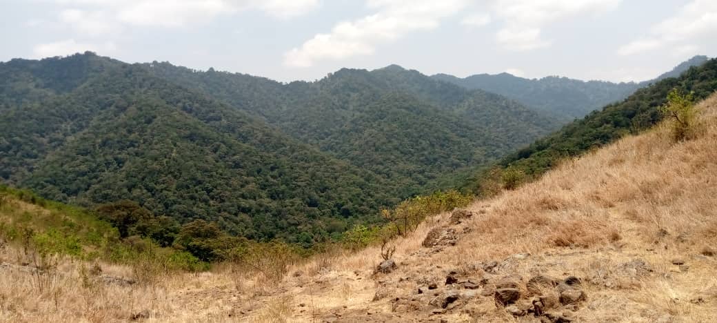
Along comes geo maps and as roads and trails get marked I notice in 2020 that on the top of southernmost peak is the start of a jeep track that crosses the top valleys and down to the plateau on the west.  They are hunting tracks and visible by satelite.  The problem is I get up there on foot but cant find a way the last 1/2 km to the track.  It is thick bush and bamboo forest.

Along comes Elliot.  He moves  to a house half way to the forest on the Monduli slopes and explores.  In December 2021 Elliot tells us he has gotten on to the south peak by way of a faint trail from the next peak over, but on foot.  I quickly check his gpx track and he has made it on to the jeep track!  

A month later he takes us up but we stash the bikes as the trail is not only steep but a little overgrown , making pushing the bike through hard and riding down impossible.  We get to the top and see what might be jeep trail but then are spooked by an unseen buffalo and we head down.  

The rains start and it is forgotten about until October 2022 when Elliot says the cows have opened up the trails and he went up and over into the valley and saw the jeep tracks.  Immediately 3 old guys start planning a trip for next weekend.

The rest is me ticking off an item on my bucket list

I start at 530 using headlight to meet with Mike at 6 am.  There has been a big rain and we pick up mud, almost enough to lock up the tyres.  We meet up with Elliot and resort to gravel roads to take us up to the forest.

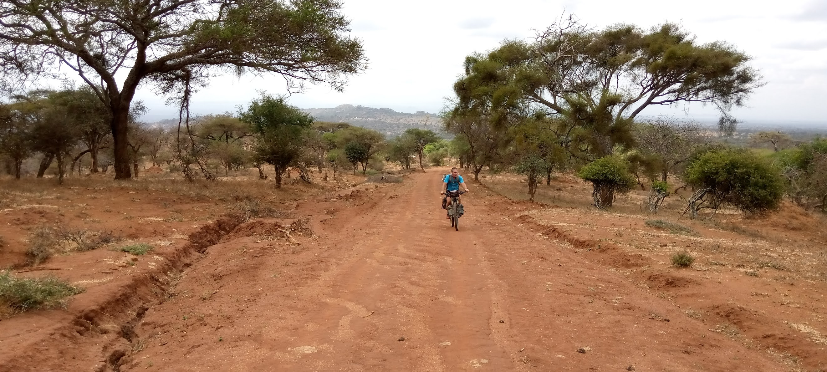
You can see Mike pushing and my tyres have sunk in soft  sticky soil


Mtn meru where I came from


Cows are sleeping up in the forest and the trail is open but slippery


Views down and of the small foot trail


Showing the steep narrow slippery trail.


First glimpses of the top


On the left a jeep track is visible going up a slope.  


After a section on tough foot path but at least downhill we make the road.  It is beautiful pristine forest.

Wonderful experience.


We ride downhill for 20km and 1400m drop to mondulli town and eat lunch if a restraunt and sit around a bit deciding the route to finish.  Unfortunately monduli slopes are highly eroded.  if we contoured we could make Elliots house easy.  unfortunately from the track you can see we have to go up and down the mtn to get around big erosion gulleys.

We make Elliots house and i decline a beer knowing getting going would be a pain.  I do a couple of up and down on big valleys, slog through Likamba and coast down to TPRI and hit the tarmac.  around 100km.  Stop for a couple of beers before going home.  

That night is the World cup opening and i watch it in a crowded noisy bar in sakina.


04 August 2021

Trying for South Masai Steppe

 Saturday night I look at maps and think what would be an interesting loop, but I don't manage a decision.  that continues as I get up and do my morning routines.  I wake before light at 530 but this and that makes it closer to 830 before I leave.

Somehow i manage a decision to ride a loop south onto the south masai steppe.  I will go south on the main gravel road to the east go up on the steppe to Terat and then smaller tracks back from there passing Shimo la Mungu.  That was the rough plan


Good roads, a bit of washboard the second half of the morning.  Some motorcycle paths along the main road to avoid gravel road.

I passed a guy on a clunker with shamba tools on his bike and 20 minutes later he passed me and i could benefit from him knowing with motorcycle tracks were worthwhile


A little over three hours and I am climbing the escarpment. It is almost 400m elevation.  The top was always around another cornor.  When it leveled off and turned west i was hungry and wanted to get in the hammock a bit and enjoy life even more.  I tried to find two trees suitable with shade and a view .  I settled for two trees in the sun and no view while in the hammock.  Ate every food and snack I had.


This is the view when i started back from top of steppe.  I realizied not enough time to do a loop but head back the most direct way.


It was ten hours, 150km.  arrived near my home just at dark and had a couple of beers.  Great ride.

29 June 2021

Lolkisale, Losimingori, and Monduli Mtns tour.

Four day bikepacking tour to different mtns.  Route was unplanned.  Mike and I got our schedules in sync to do another bike pack trip.  I had finger surgery and it finally healed but it bothered me some.


We rode familiar trails, tracks and roads to Lolkisale.  Lisa escorted us for a bit.


starting to climb up to Lolkisale mtn.  it sits out by itself with lots of rock outcroppings.  About here we shooed and cameleon off the road so it wouldn't bite the dust.


Then up the communication tower road to the top of Lolkisale mountain.  First part was doable to get on a ridge. not overly steep


Starting to get good views.


Then it got steep or rocky, sandy,  or all three.  They had actually put concrete down but it was broken up.
Higher up it was smooth but steep.

Starting to reach the montagne forest.

My company has a communications tower at the top.  One of like 10.  So we were expected and well looked after.  This is the gate to ours
Mike enjoying the late afternoon with the towers in the distance.  We moved down from the very top to an open grassy place surrounded by trees.

Lots of firewood and plenty of cold.  so we had a fire and sat around in the wind.


In the morning the fog was thick.
My hammock in the trees.
While breaking camp a small herd of buffalo crashed through the forest below us.  We didnt get a glimpse but certainly heard them.

Descending was easier but still I had to walk a few rough sections

We rode a trail we knew west and then took a track to take us north towards Losimongori mtn.

We hit the highway around Makyuni.  Stopped for lots of food and water.  ten kms from Makyuni we decided to move off the road and look for tracks going up the mtn. We were in overgrazed scrub.  we came upon a good track and immediately the habitat became good bush, high dry grass, mature trees, and thick .

Met some young herders and they said camp anywhere.  So we camped here.  Had to chase some eland and zebra off our camp site.

Great camp site.

Calling home


Next day me continue gradually to the base of Losimingori mtns and come upon this camp.  Turns out this was Steins place and is now a WMA wildlife area.  This old man stayed on all these years looking after the place.  everything was run down but we were told there was a ranger post up top.


I must say now the trail got very interesting.  Lots of sign of Elephant all over as we were following a drainage with water.  Thick bush.

Checked out the water flow.


Came into an opening and we glimpsed a land cruiser parked on the other side and sounds of someone chopping wood.  luckily the road forked going out of the drainage.  so we took this steep track and came into cool open grasslands as we contoured around the mtn.


Another fork,  one road going up to the top where we were told was a hunters camp.


We were so luckily to be able to ride this track.


After a tiring up and down section in the heat we came to the highway and one of the villages hugging the highway.  Ordered food, sodas, water, chai, and eventually a couple of beers and had a good rest.
I added 2 litres of water on my back seat post rack as we wont get water until mid next day.


Took some tracks the the Nanja dam.  Lots of people washing clothes on the lower side of the dam, we rode a bit and then took a bath and swim in the water.  refreshing.

now we were on a good gravel road, which was new to us.  it started to head up to monduli juu plateau. As we started to hit a village we turned around to camp in a Accacia drepanelobium forest.  heading there i went through a ditch and snapped the seatpost rack and it sat on the tyre.  i balanced it on the handle bars and caught up to mike and we camped.  nothing spectacular about the camp.